Optimal Technological Approaches for Enhancing Construction Site Layout Planning Efficiency
Nur Fadilah Darmansah1*, Nadirah Darus2, Zafira Nadia Maaz3, Nur Arzwin Mohamed Aris4, Teo Yi Xian2
1Universiti Malaysia Sabah, Kota Kinabalu, 88400, MALAYSIA
2Universiti Teknologi Malaysia, Johor, 81310, MALAYSIA
3Universiti Malaya, Kuala Lumpur, 50603, MALAYSIA
4Universiti Tun Hussien Onn, Johor, 86400 MALAYSIA
The layout design of a construction site includes the careful planning and placement of all necessary facilities to support various construction operations and tasks before building begins. The purpose is to figure out the optimal location for all essential facilities and enhance the resources and processes for the construction project. This strategy frequently results in imprecise planning of the site layout, dependent on experience, basic 2D drawings, and intuition. The unique environment and spatial limitations of each construction site can result in inaccurate site layout plans. Therefore, this study to identify technology strategies that can be adopted to improve construction site layout planning. The research used a quantitative methodology to gather data from designated respondents, specifically the G7 building contractors registered with CIDB in Johor. Sixty-five (65) respondents completed the questionnaires. The respondents comprised 21 quantity surveyors, 17 site supervisors or engineers, 11 other supervisory construction professionals, 7 project managers, 5 engineers (including electrical, mechanical, civil, and structural), and 4 safety officers. The data analysis conducted using SPSS employed descriptive methods, including frequency and mean analyses. Various factors using to identified which technology can enhancing construction site layout planning efficiency including visualization capabilities, time savings, accuracy and reliability, collaboration and communication and user-friendliness. The results demonstrated that building information modelling (BIM) was favoured as the technology most likely to improve planning for building site layouts, achieving a mean score of 3.94, while virtual reality (VR) was seen to have the least potential, with a mean score of 3.58. In conclusion, this study highlights the consequences of insufficient construction site layout planning to alert site layout planners to be more mindful of inadequate and simple layout planning. This study advocates for the gradual integration of this technology into existing methodologies for planning construction site layouts to enhance their efficacy. This is due to its significant ability to generate and provide more precise and dependable blueprints for construction site layouts.
As construction sites expand in scale and intricacy, it is essential to devise optimisation approaches that improve the operational efficiency of the construction sector (Hawarneh et al., 2021). A critical determinant influencing productivity, safety, and efficiency in construction activities is the site layout utilised during different phases of development (Sestras, 2021). Site layout design refers to the arrangement of temporary facilities necessary for construction activities, including material storage, fabrication zones, and parking, in optimal positions within the available site area. The process of planning the site layout fundamentally entails the planning, design, and placement of all requisite facilities to facilitate operations conducted during construction (Kim et al., 2021). While CSLP is not directly associated with the project’s technical specifics, inadequate site architecture may adversely affect the overall budget due to heightened material handling time, extended lines, and diminished worker productivity (Liao et al., 2011). The appropriate arrangement of processing facilities can enhance the sustainable performance of construction projects (Tao et al., 2022).
Salah et al. (2023) assert that planning a building site is complex due to the distinct constraints associated with each project. Site planning decisions are generally made by logistics specialists tasked with designing the site layout, arranging the physical delivery of supplies, and managing material handling on site (Dubois et al., 2019). The placement and allocation of these facilities during construction are determined by the available space on site. The types and sizes of on-site facilities may fluctuate over various development phases. Many construction projects necessitate numerous temporary facilities. These facilities must be situated inside the designated site area, and their placement might influence essential success aspects, including productivity, safety, and cost during the construction process (Benjaoran & Peansupap, 2019; Wang et al., 2019). Razavialavi (2016) asserts that the sort of facility required for a project is contingent upon the project’s needs regarding supporting activities and adherence to safety and health laws.
As of now, construction site layout planning (CSLP) has been conducted using manual techniques based on experience and intuition (Ji et al., 2022). Occasionally, these planning decisions may be inadequate and erroneous, leading to a dangerous site configuration (Abune’meh et al., 2016). Elgendi (2016) stated that the placement of on-site facilities is determined by experience, common sense, a first-come, first-served basis, and precedents from prior design. Nonetheless, they are unable to integrate all variables that may affect facility selection, location, and linkages.
Furthermore, Kumar & Bansal (2018) indicate that practitioners have conventionally designed site layouts using traditional techniques, including manual sketches on paper and basic 2D drawings with computer-aided draughting (CAD) software. Conventional site layout planning has historically relied on two-dimensional floor drawings, including simpler geometries (Álvares & Costa, 2019). A two-dimensional representation of the site constrains the project team’s comprehension of the intricacies inherent in on-site project development. Inadequate site layout planning can result in significant waste due to the superfluous movement of materials and resources on-site (Singh & Delhi, 2018). Most site layout plans assume a flat building area, which is impractical and unrealistic, as topography and terrain influence the distance and pathways of the site (Razavialavi, 2016). Presently, location layout planning relies on a two-dimensional floor plan of the location. Due to the inability of paper drawings to offer a three-dimensional viewpoint, planners encounter challenges in their planning processes (Singh et al., 2017).
Ahmad et al. (2019) further noted that in conventional approaches, the contractor employs two-dimensional (2D) drawings, PDF overlays, or hand-drawn illustrations to create site layout designs. Traditional 2D designs are susceptible to inaccuracies and discrepancies, frequently resulting in a lack of transparency and errors in subsequent processes. Contractors use traditional site layout techniques grounded in expert judgement, utilising straightforward planning informed by preceding knowledge and experience, and employing 2D drawings as a vehicle for stakeholder engagement. The traditional site layout plan remains unaltered throughout the project lifecycle (Singh & Delhi, 2018). Consequently, by minimising the error rate stemming from experiential and trial-and-error methodologies, judgements will rely on analytical outcomes, as initial planning errors can trigger a cascade of adverse effects on manufacturing processes. To mitigate this adverse effect, it is essential to engage in planning with assistance to reduce potential future harm (Atmaca & Akcay, 2021).
Moreover, altering site layout decisions might be challenging or expensive as the project advances. Consequently, formulating an appropriate site layout plan is essential for efficient building and maximising output. An effective construction site layout can minimise material movement, enhance labour productivity, reduce costs and schedules, improve worker safety, and positively influence construction quality (Small, 2016). It is essential to recognise that the on-site strategy will dictate the overall duration of personnel presence during the building phase. Consequently, meticulous pre-planning is essential (Elyamany, 2018).
The incorporation of contemporary technology, including Building Information Modelling (BIM), Geographic Information Systems (GIS), Artificial Intelligence (AI), and the Internet of Things (IoT), has transformed the planning and management of construction projects. These technologies provide real-time data analysis, predictive modelling, and automation, empowering project managers to enhance space usage, increase workflow efficiency, and mitigate potential risks. Furthermore, digital twin technology and drone-based surveys enhance site mapping accuracy, minimise errors, and facilitate superior decision-making. Below are several technologies employed to enhance site layout planning.
Adoption of Virtual Reality (VR)
Virtual reality (VR) is a technology that can simulate both present and future reality by replacing the real world with a computer-made one. Because VR technology has grown so quickly in the past few years, professionals in the construction industry should use it. This can significantly enhance the digitisation of building sites and ensure the appropriate allocation of resources for each project. Because there are so many factors and things to think about, worksite developers have started using new technologies to accelerate the process. VR technology is a beneficial way to check operations and processes that happen on-site (Kan & Azhar, 2016). It gives managers a look into what will happen with the project in the future and helps them understand their needs and problems before they happen. As part of the logistics plan, site planning can include things like equipment traffic paths, a safe place to work, the location of material stocks, and the number of available workers.
It was decided that site access, crane placement, trash disposal, material placement, excavation dirt stacking, office placement, equipment placement, and site orientation should be considered when planning a construction site layout. These things can be better organised with VR tools (ElNimr et al., 2016; Hammad et al., 2017; Razavi-Alavi & AbouRizk, 2016). A study looked at how useful it is to use VR technology for planning the layout of a building site. It compared 2D, 3D, and 4D models with VR models. The results showed that 102 people preferred 3D models with VR because they were more useful and reliable. Based on a Likert scale with 1 being the least effective and 5 being the most effective, the 3D VR method got the best mean score from the respondents, followed by the 3D model and then the 2D, with scores of 4.4, 3.9, and 3.0, respectively. Planners on construction sites can use the suggested visualisation technology to make setting up tasks on sites run more smoothly. This technology can help site planners and construction managers see how a job site is laid out. Adopting VR can provide a more comprehensive description of the site plan and help visualise the available space on the site. Examining the current usage of a room on a construction site can lead to the development of an improved strategy (Ahmad et al., 2019).

Figure 1 User’s View through the VR Headset for Site layout Planning
Source: Ahmad et al., 2019
Adoption of Augmented Reality (AR)
AR (or augmented reality) is a technology that overlays digital information onto the real Augmented reality (AR) is a technology that superimposes digital information onto the physical environment. Augmented reality can modernise building site layouts and surveys by providing increased visualisation and interaction capabilities. Augmented reality (AR) can be used to preview and adjust layout plans, simulate and evaluate various situations, train and instruct site personnel, and facilitate communication and collaboration with stakeholders (Wang, X.2018). Experimental results conducted by Singh et al. (2017) indicate that augmented reality (AR) has emerged as a significant tool in site layout development. The project demonstrates the transformative effect of augmented reality on critical elements of the planning process by emphasising its significant role in addressing the inherent limitations of conventional 2D mapping techniques. AR considerably improves the visualisation of intricate site layouts by offering immediate and thorough insights. This enhanced visualisation can facilitate more effective communication between teams by mitigating issues related to comprehending and delivering solutions. This experiment demonstrates AR’s capacity to assist less experienced team members, enhancing their confidence in generating solutions and fostering an equitable decision-making atmosphere. The use of augmented reality has been shown to quickly find and get rid of solutions that aren’t practical, saving time and making designs more likely to work. The technology affects targeted solution searches, where AR-enabled talks talk about things like cost and time, making it easier to look at all of the options that are available. In contrast to traditional two-dimensional drawing, augmented reality goes beyond its limits, allowing faster learning of new information and rethinking of solutions that were ruled out in earlier stages. This experiment underscores the pivotal significance of augmented reality in site layout planning, enhancing visualisation, communication, decision-making processes, and overall planning efficiency.
The best thing about AR tools is that they are easy and quick to set up for construction site planners. This means that even people who have never used a smart system before can easily use it. Augmented reality interfaces help users become immersed in enhanced realities by using creative, light, and inexpensive ways to interact with and display computer-generated content. The implementation of augmented reality as a novel user interface offers a fundamentally different methodology for the design of building site layouts. It facilitates the expeditious planning of construction sites and enhances their quality. AR Planner allows construction site planners to position building materials, machinery, handling equipment, and associated wiring within the designated site (Wang, 2018). Additionally, AR Planner employs 3D models to depict these objects in the virtual realm. Users can dynamically manipulate and arrange these objects to design and establish construction site layouts as illustrated in Figure 2. Augmented reality features help plan the layout of a project site by providing detailed information and 3D digital objects that can be used on the real project site (Singh & Delhi, 2020).
Figure 2 Augmented Reality in Site Layout Planning
Sources: Singh & Delhi, 2020
Adoption of Building Information Modelling (BIM)
BIM can be a central source of information that makes it easier for people to work together and see what’s going on. It can also help you see possible problems before they happen and make planning more effective. BIM has a lot of promise for planning the layout of a construction site so that people can work together and see what they are doing. However, we haven’t fully utilised BIM’s potential in planning the layout of a place yet. In the beginning stages of planning, a flat drawing of the building site is used to show where the buildings will go. Planners and managers utilise these drawings to create plans for the portable buildings required for projects and construction. Because of this, these 2D drafts or plans are critical for planning. However, these visual aids may not convey the same information to every team member involved in planning. This could be because of different levels of intuition, knowledge, mindset, and time spent in the planning field, among other things. So, to avoid misunderstandings and poor communication between teams when planning with 2D sketches, it is suggested that these planning processes be improved by adding 3D BIM models of the project along with the necessary support tools (Singh et al., 2017).
BIM’s accurate and detailed project information makes it a great tool for construction managers to deal with many problems in the industry, especially those related to planning the layout of a building site (Le et al., 2019).Some experts also use project schedules along with BIM to find the best site layout on the fly. For example, Wong et al. (2015) used a BIM model and a building schedule to figure out how much material they would need and how to best set up their tower crane. These models can change the layout of the site on the fly based on different stages of building with the help of BIM models and schedules (Tao et al., 2022). It is suggested that a framework based on BIM be used that automatically estimates the size, dimensions, and number of buildings using data from BIM and schedules. The plan of the site should also be added to the current BIM model. BIM-based site layout planning not only gives you a 3D model of the site tools (see Figure 3) that you can easily use to make a 2D site layout plan, but it also uses 5D data to help you make plans and estimate costs (Schwabe et al., 2016).
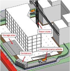
Figure 3 Site layout planning by using BIM
Sources: Schwabe et al., 2016
Adoption of Geographic Information System (GIS)
The construction site is integral to the surrounding environment and influences it; therefore, it should not be planned in isolation from its context. The building’s placement on the site will significantly influence its construction plan. A project constructed in one location will employ distinct construction methods compared to a project at another location with varying site characteristics and topography, as it will pose different problems (Bansal, 2016). A study by Bansal (2020) revealed the advantages of employing GIS in construction planning. Research indicates that GIS can assist users in identifying potential conflicts in construction plans, scheduling operations, simulating the construction process in 4D, identifying drainage regions for construction sites, and estimating the volume and area of excavation and backfill. Kumar and Bansal’s (2018) study looked at how GIS can be used to find safe and suitable places for temporary facilities on-site, taking into account the area and topology. A different study found that combining GIS features with construction site layouts can greatly improve safety on these sites, making it easier to suggest safety rules and lowering the number of fatalities at work through preventative measures (Sarasanty, 2020).
BIM’s application is constrained in that it analyses factors such as environmental conditions, access routes, topographical positioning, thermal comfort, and the formulation of safety measures, including the evaluation of materials for new sites impacted by flooding, ingress and egress routes for supply vehicles, and drainage planning (Liu et al., 2018; Ning et al., 2019; Song, Xu, Shen, & Pena-Mora, 2018). Geographic Information Systems (GIS) assist planners in modelling spatial linkages and the geometric and topological restrictions that present problems for the architectural elements on the site (Song, Xu, Shen, & Pena-Mora, 2018; Wu et al., 2017). Recently, GIS has been utilised for the secure placement of temporary infrastructure in mountainous regions (Atmaca & Akcay, 2021).

Figure 4: Site Layout Planning Using GIS
Sources: Atmaca & Akcay, 2021
Adoption of Unmanned Aerial Vehicle (UAV)
Unmanned aerial vehicle (UAV) systems, generally referred to as drones, are a technology applicable for site layout planning (Rizo-Maestre et al., 2020). A solitary UAV frequently employed at construction sites comprises a remotely operated aircraft outfitted with a dependable Global Positioning System (GPS) for real-time positional reference, a control station, and various onboard sensors, including obstacle avoidance technology and image acquisition and transmission systems (Grosso et al., 2020; Hassanalian & Abdelkefi, 2017; Jeelani & Gheisari, 2021; Lee et al., 2020). Numerous studies have investigated the potential of UAVs for various uses, including site planning. Site engineers and planners now possess a tool that provides comprehensive and current information regarding the logistics and advancement of construction operations (Albeaino & Gheisari, 2021). The adaptability and agility of drones facilitate access to inaccessible locations and efficiently survey extensive areas (Leksono et al., 2019; Sestras et al., 2020; Tian et al., 2021), with the provision of visual data through photographs or live video being one of its most appealing attributes (Freeman et al., 2021 & Jiang et al., 2020).
Information obtained from drones can assess many criteria, such as proximity to access channels, inter-facility distance, and geographical suitability. This maximises spatial efficiency and progressively diminishes internal transportation expenses. Identifying safety risks and hazards linked with construction activities is crucial for site layout planning. These can be identified from processed photographs acquired by drone technology. The implementation of drone systems enables meticulous monitoring of alterations at the construction site and facilitates the updating and verification of journey frequency between site facilities. (Hammad et al., 2021). Additionally, Palcis (2023) has illustrated the capacity of UAVs to improve construction site design and planning. The utilisation of drones in building site design and planning can markedly enhance precision and efficiency relative to conventional methods, with the potential to transform the approach to construction site design and planning.

Figure 5 Application of Drones in Construction Site
Location & Population of Study
65 Respondents selected for this study are Grade 7 company contractors registered with the CIDB and are limited to Johor state.
Instruments
A questionnaire will be prepared and designed using the Google Forms feature. In Questionnaire various aspects including visualisation capability, time savings, accuracy and reliability, collaboration and communication, and user-friendliness. Questionnaires will be delivered to the mentioned respondents both physically and non-physically and will proceed to data analysis once the study has reached the specified number of responses.
Data Analysis Method
The data analysis in this research encompasses descriptive analysis(frequency and mean analysis), reliability analysis, and normality analysis, each serving different purposes and holding importance to this research. The data analysis will be undertaken using SPSS software for an efficient and faster data analysis experience. Once all the data have been thoroughly analyzed, an in-depth discussion and conclusion will be made based on the analysis results at the end of the study.
The research findings focus on the analysis of identified technologies that could potentially improve construction site layout planning in Johor. A variety of advanced technologies, including Virtual Reality (VR), Augmented Reality (AR), Building Information Modelling (BIM), Geographic Information System (GIS), and Unmanned Aerial Vehicles (UAVs) or drones, are utilised to enhance the planning of construction site layouts. Figure 6 provides a summary of the technological strategies that Johor can implement to improve building site layout design.
After comprehensive analysis of each technology from multiple viewpoints, it is clear that Building Information Modelling (BIM) stands out as the optimal choice for improving planning of building site layouts. The technology consistently demonstrates elevated mean scores across various dimensions. BIM exhibits considerable potential to transform site layout design methodologies, evidenced by its highest overall mean score of 3.9415. This highlights BIM’s adaptability and efficacy in managing the intricacies of site layout planning. Respondents indicate that Building Information Modelling (BIM) is the most preferred technology for improving construction site layout design in Johor. This discovery aligns with prior research that has thoroughly examined its potential and relevance in site layout planning. In traditional site layout design, structures are usually depicted in a two-dimensional style, often leading to inefficient and unreliable layouts. This traditional method significantly depends on individuals’ visual acuity, inadequately guaranteeing consistent comprehension across team members and lacking the ability to replicate exact site conditions. Conversely, BIM provides a solution by acting as a centralised platform that enhances cooperation and visualisation in site layout planning. BIM facilitates uninterrupted communication among team members, foreseeing potential risks and improving planning efficiency. The recommendation for its implementation in site layout planning arises from its capacity to alleviate problems associated with misunderstanding and misinterpretation of 2D drawings across teams, therefore enhancing the entire site layout planning process (Singh et al., 2017). Additionally, academics have investigated multiple methods to link BIM with project timelines to consistently enhance site layouts. Wong et al. (2015) employed BIM models and construction schedules to assess material consumption and enhance tower crane arrangement strategies. Moreover, BIM offers comprehensive 3D representations of site equipment and facilities, facilitating the assessment of size, dimensions, and quantities (Schwabe et al., 2016). The extensive project data provided by BIM is an essential resource for construction managers in effectively tackling various difficulties in the construction sector, especially those concerning site layout design (Le et al., 2019).
Unmanned Aerial Vehicle (UAV) or drone technology ranks as the second technology that could potentially improve construction site layout planning in Johor, with an overall mean score of 3.9077, nearly matching that of Building Information Modelling (BIM). The respondents acknowledge the potential of UAVs to significantly enhance site layout planning procedures, indicating it as an effective tool for improving efficiency and precision. Numerous studies have underscored the potential of UAVs in coordinating construction activities, including site layout design (Albeaino & Gheisari, 2021). Unmanned aerial vehicles (UAVs) provide remarkable flexibility and manoeuvrability, allowing planners to securely and correctly visit difficult-to-reach locations (Leksono et al., 2019; Sestras et al., 2020; Tian et al., 2021). UAVs can capture photos and film videos of construction sites (Freeman et al., 2021; Gheisari & Esmaeili, 2019; Jiang et al., 2020). The deployment of UAVs allows for the identification of distances between facilities, the appropriateness of facility locations, site safety concerns, and hazards; hence, it provides continuous monitoring and enhancement of site layout efficiency, which enables planners to optimise space utilisation (Hammad et al., 2021). According to Palacis (2023), using UAVs can make site layout design much more accurate and useful than traditional methods. It has the potential to completely change the way site layout is done.
The subsequent analysis of Geographical Information Systems (GIS) demonstrates its efficacy in enhancing site layout planning, with a total mean score of 3.7846. Their average results indicate significant potential to improve site layout design processes, but to a lower extent than BIM. The site of construction profoundly impacts the superstructure above it. A project would utilise unique construction techniques compared to similar projects because of the specific topography and elevation, which provide different challenges in building (Bansal 2016). Geographic Information Systems (GIS) can be employed in site layout design to identify potential conflicts in construction plans, delineate drainage areas for construction sites, and aid in estimating the necessary area for excavation and backfill (Bansal, 2020). Kumar and Bansal’s (2018) research demonstrates that GIS may efficiently identify safe and appropriate locations for temporary amenities at building sites, considering the site’s geography and topography. GIS aids planners in discerning spatial relationships and addressing geological and topological challenges at construction sites (Song, Xu, Shen, & Peña-Mora, 2018; Wu et al., 2017). Thus, GIS can function as a potent tool to diminish the occurrence of accidents and fatalities when utilised in site layout planning (Sarasanty, 2020).
The fourth technology applicable for improving building site layout design in Johor is Augmented Reality (AR), which has an overall mean score of 3.6369. A. Singh et al. (2017) showed that augmented reality significantly improves the visualisation of complex site layout plans, hence reducing misunderstandings and misinterpretations common in traditional site layout design. This capability improves team communication and collaboration, facilitating the swift identification of solutions that may be overlooked by conventional methods. Even inexperienced users benefit from augmented reality, which provides improved site layout suggestions. Moreover, augmented reality is relatively simple, lightweight, and readily implementable, allowing even novice users to understand the system and reducing the time required for site layout planning (Wang, 2018). The construction team can cooperate by employing augmented reality to place digital 3D replicas of site facilities or equipment within the physical environment, thereby improving operational efficiency and dependability. Thus, augmented reality can enhance the process of developing site layouts in the building industry (Singh & Delhi, 2020).
Conversely, virtual reality (VR) appears to be the least preferred technology for improving site layout planning, evidenced by its lower mean scores across several parameters and the lowest overall mean score of 3.5846. These findings highlight possible constraints and concerns associated with VR. Nevertheless, it is crucial to recognise that virtual reality retains the capacity to improve planning for construction site layouts, despite its constraints and challenges. Virtual reality (VR) is the least preferred technology among respondents; yet, it remains a feasible option, as indicated by a high mean score that highlights its potential in site layout development. Virtual reality is acknowledged for its ability to replace the physical world with a computer-generated environment and demonstrates potential for mimicking the conditions and surroundings of a construction site (Kan & Azhar, 2016). Site access, tower crane placement, waste management zones, material distribution, excavation areas, and supplementary site offices and equipment can be effectively arranged and planned using virtual reality (ElNimr et al., 2016; Hammad et al., 2017; RazaviAlavi & AbouRizk, 2016). A study by Ahmad et al. (2019) revealed that virtual reality received significant approval from participants, with a mean score of 4.4. This suggests that VR has significant potential to improve the efficiency of site layout planning through its sophisticated visualisation skills and thorough representation of the worksite. The study concludes that concerns regarding VR technology include its significant understanding requirements, intricate training demands, hefty cost commitments for contractors, and privacy concerns (Watson, 2020). These concerns may deter some respondents from considering it a feasible method for site layout planning. Nonetheless, Virtual Reality (VR) can substantially improve site layout planning processes, as evidenced by its higher mean score.

Figure 6 Technology Strategies that can be Adopted to Improve Construction Site Layout Planning
Five technologies have been identified are Virtual Reality (VR), Augmented Reality (AR), Building Information Modelling (BIM), Geographical Information System (GIS), and Unmanned Aerial Vehicle (UAV) or Drone. To assess the potential of each technology in improving construction site layout planning, various assessment criteria or aspects have been provided in the questionnaire, including visualization capabilities, time savings, accuracy and reliability, collaboration and communication, and user-friendliness. Respondents were asked to express their agreement with each technology in different aspects using a Likert scale questionnaire ranging from 1 to 5, where a higher number indicates stronger agreement. The feedback will be analysed and discuss the most to least agreed technologies that can be adopted to enhance construction site layout planning based on the overall mean score of each technology. In conclusion, respondents in our study strongly agree that the technologies identified in the literature review have significant potential to improve construction site layout planning practices in Johor. The overall mean scores for each technology range from 3.41 to 4.20, indicating a high level of agreement. Based on these results, this research recommends that site layout planners and related teams can try to adopt these technologies to enhance the site layout planning process.
Further study should evaluate the cost-effectiveness of using these technologies in construction projects in Malaysia. This study aims to evaluate the cost-effectiveness of incorporating these technologies in construction projects, as cost-benefit analyses are essential for all contractors. The analysis will involve a comparison of expenses before and after the integration of these technologies into site layout planning. If these technologies significantly reduce construction project costs through improved site layout design, contractors may be incentivised to use them, potentially revolutionising the site layout planning process. This objective presents considerable challenges for researchers, who must rigorously account for additional variables that could influence building project costs and lead to misinterpretation. These variables may include the project kind, the quantity and proficiency of personnel and equipment utilised, and the expertise of site managers, among others.